The race to save Kahoolawe’s sacred stone
It's a rare archaeo-astronomonical tool aligned with the sun, moon and stars.
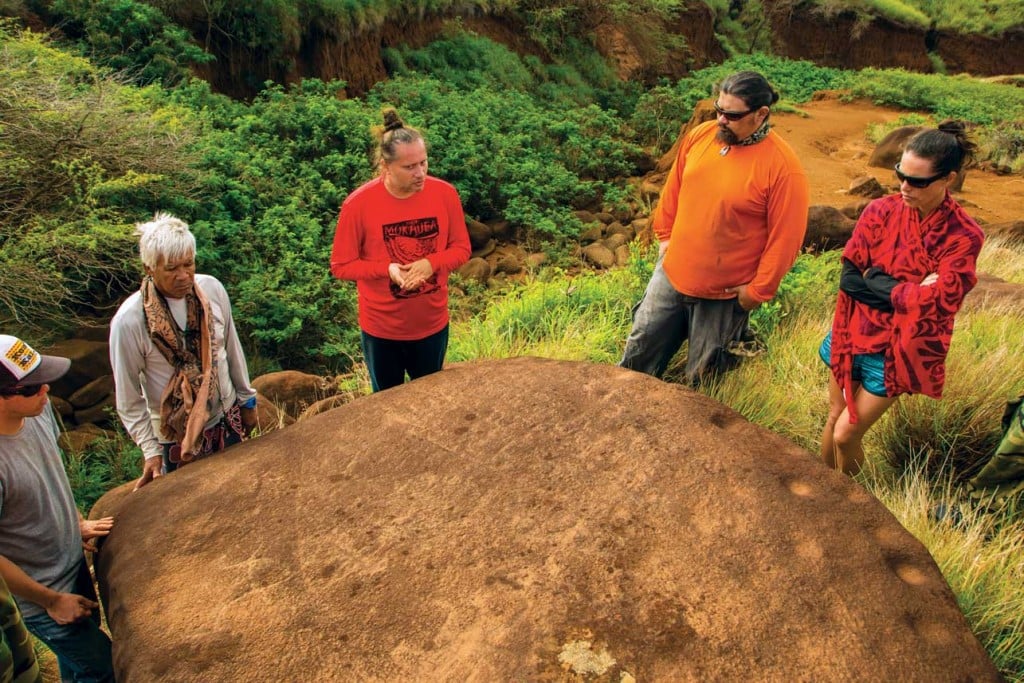
Along the southerly slopes of Kahoolawe, a sacred pohaku (rock) is poised dangerously at the edge. The flat boulder, about 12 feet in diameter and etched with petroglyphs, sweeping lines and 32 poho, or pecked man-made cupules, lies horizontal from the precipice of a fast-eroding ravine. Elevated 20 feet high, believed to be purposefully aligned with the sun, moon and stars by ancient Hawaiians, the 4-ton pohaku’s greatest threat is the land itself. Due to the site’s widespread and inevitable erosion, with the soil shifting at a precarious rate of 3 millimeters a year, the rock’s fate quite literally hangs in the balance.
Cue a hui (team) on a mission to save it. On March 13, a band of five scientists—four engineers and an anthropologist—touched down on Kahoolawe, a restricted island, for the next phase in a treatment plan to stabilize the pohaku. Situated at the edge of Kaneloa Gulch, the endangered relic’s name is PoKaneloa (a contraction of Pohaku and Kaneloa) and its markings are believed to be an earthly, conscious reflection of complex celestial movements, timed with the solstices and equinoxes, making it a rare archaeo-astronomonical tool.

“It’s a geo-heritage site under threat,” says Lelemia Irvine, a Native Hawaiian Ph.D candidate in civil and environmental engineering at the University of Hawaii at Manoa, who’s been partly tasked by the Kahoolawe Island Reserve Commission (KIRC) and the Protect Kahoolawe Ohana (PKO), the island’s two restoration stewards, to assess the site’s vulnerabilities and collect comprehensive data that will advise the steps needed to best maintain it.
During the course of three days on the island, the crew set up eight solar-powered video cameras to capture 24/7 digital surveillance of PoKaneloa for an entire calendar year. The ongoing footage filmed is primarily monitoring how shadows are cast upon the stone as the sun travels across the sky (a pole has also been set up to mimic how a kahuna, or priest, in this case, one who specialized in observing celestial bodies, may have engaged with the rock, holding a long upright stick vertically at either end of the stone) to gain a richer understanding of its usage. That no entity today can authoritatively say what it was used for makes this mission all the more crucial; it would give modern-day archaeologists, anthropologists and cultural practitioners the ability to validate their hypotheses about how PoKaneloa was used: Was it a calendar? A navigational tool? Were the cupules, when filled with water, used as a reflector to also study the moon and stars? Is its purpose all of the above?
PoKaneloa isn’t about answers, but these questions it inspires. “It’s a new-old discovery,” says Irvine. “It’s new to us, but it’s still old and was in the consciousness of our ancestors.” In saving the stone, PoKaneloa serves as a testimony “to the intelligence, training, spiritual guidance and experience that were needed to settle on the immediate location” where it resides, explains the Edith Kanakaole Foundation, one of the pohaku’s principal authorities, in a 2009 report expounding its cultural legacy.
“It’s an amazing and unique cultural treasure,” says Dr. Davianna Pomaikai McGregor, a Hawaiian scholar with more than four decades of cultural and field research on Kahoolawe, and a spokesperson for PKO. “The pohaku is part of a system our ancestors developed for their observation, and, if we can re-understand it, that will get us closer to reconnecting with that deeper scientific ancestral knowledge our ancestors had been able to perfect.”

Insomuch, PoKaneloa is regarded as more than a rock—it’s a cultural resource and intelligence system, a tool once used by ancient Hawaiians to intentionally observe elaborate astronomical movements and natural phenomenon. According to the Edith Kanakaole Foundation’s initial surveys, it’s the only rediscovered artifact of its kind in all the Hawaiian Islands. It’s an “intangible” antiquity “as close to precontact as we’re going to get,” Irvine adds. “That’s where the severity and importance is.” Should the pohaku tumble in the thick of night and crack in the gully beneath, future generations will never fully know its purpose or its testament to the ike (knowledge) Hawaiians embedded and expressed through it.
The rock itself is actually part of a larger site, where just yards away, other massive boulders, some with carved petroglyphs and on more secure ground, are seemingly related. This area is called Loaa, which in Hawaiian means “to find, discover,” and is considered to house the oldest and rarest set of recorded petroglyphs on Kahoolawe, dating back nearly 600 years. A 1993 field survey by Georgia Lee and Edward Stasack believes the site could have once contained additional boulders with petroglyphs that have already been lost.
“What makes PoKaneloa sacred is not just the rock itself, but it’s the wahi pana (sacred place), its location, all the pohaku and the surrounding environment,” Irvine says. The entire island of Kahoolawe, located 7 miles off Maui, holds an enduring reverence by Hawaiians. In ancient times, the island was referred to wholly as Kanaloa, the akua (god) of the ocean, echoing its distinction as a learning center for deep-sea voyaging—kahuna and navigators would study, train and pass down knowledge about Pacific migrations here. This eminence, however, has been eclipsed by an uneven modern history. During the 1830s, Kahoolawe was used as a penal colony, followed by ranching in the 1850s, where overgrazing by goats and cattle decimated much of the natural vegetation; most disastrously, Kahoolawe served as a bombing range for the U.S. military from 1941 to 1990, littering the island with unexploded ordnances to this day. Despite the dramatic changes to its landscape during these years, PoKaneloa miraculously endured. Officially handed from the federal government back to the state of Hawaii, with intentions to transition it into a sovereign Hawaiian entity, part of the challenge for KIRC and PKO is to “revive and elevate the island to the status it once held as the center for scientific learning,” says McGregor, and it begins with stabilizing PoKaneloa.

This yearlong monitoring at Loaa is key to also defining what the imminent danger is for the PoKaneloa structure. Because, in addition to cameras, they’ve also set up a weather station and flow meters in Kaneloa Gulch to collect data on the hydrology of what’s happening around the pohaku, measurements concerning wind speeds, rainfall, temperature, humidity and streamflow. Through the raw data, scientists can likely calculate how much time the rock has before falling over the edge. “It’s a classical mechanics question that hasn’t been solved,” says Irvine, who suggests that by knowing the degree of incline, the rate of tilt, supplemented with data on the area’s hydrology, can determine what the critical value of collapse is—and then the speed at which they’ll need to determine a preservation method.
Because simply moving PoKaneloa is easier said than done—a last resort. Believed to have been intentionally configured at Loaa, its precise locality is intrinsic to its traditional use—to move it even an inch is to alter it forever—and the hui involved are ever-mindful of which engineering solutions are most appropriate given this context.
That’s an issue to be tackled when the situation presents itself, Irvine says, which it inevitably will. Until then, they’re preparing by developing technical adaptations from an engineering lens to save a cultural artifact, he says, which exhausts options from soil stabilization with native plants to harnessing it down with cement. “Because this is still an engineering question, but, we’re also Hawaiian, so we apply an indigenous engineering approach—in that we’re very sensitive to our practices,” Irvine says. “Some people have called this ‘voodoo science’ or ‘voodoo engineering.’ This is not.”
Night-vision cameras, flow meters, weather stations—these are new devices we’re familiar with today, Irvine says, but they shouldn’t reduce the immaterial value of implements like PoKaneloa and the adjacent pohaku at Loaa.
“All pohaku are sacred. These are the tools our ancestors had of yesterday. It is so foreign to us because we are so reliant on cell phones, compasses, GPS—most people probably can’t tell you where north, south, east or west is,” Irvine says. “These were fundamental directions that everyone knew [in ancient Hawaii] … We’re trying to reawaken that wisdom. To make the rocks speak again.” By saving PoKaneloa, they hope to let the stone’s voice be heard for generations to come.
To donate to the restoration programs on Kahoolawe, visit protectkahoolaweohana.org and kahoolawe.hawaii.gov.