The Most Popular Trails in Hawaiʻi Volcano National Park, According to Hikers
Put these five hikes on your itinerary for your next trip to Hawaiʻi Island.
Hikers agree: Hawaiʻi Volcanoes National Park has some of the most unique trails anywhere in Hawaiʻi. You can walk across a hardened lava lake from a 1959 eruption or venture through a 500-year old lava tube.
The 333,308-acre national park on Hawaiʻi Island has dozens of trails for every level, from the well-paved Devastation Trail to the grueling 7.6-mile trek to a campsite at Keauhou on the seacoast of the park.
Here are the Top 5 trails in Hawaiʻi Volcanoes National Park, per users of the AllTrails fitness app.
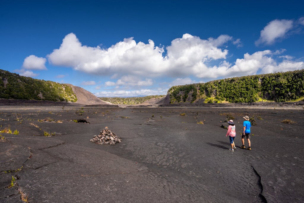
1. Kīlauea Iki and Crater Rim Trail, 3.2 miles, moderate

Hikers walk along the restored Kilauea Iki trail in Hawaii Volcanoes National Park.
Photo: Hawaiʻi Volcanoes National Park/Janice Wei
One of the most popular trails in Hawaiʻi Volcanoes National Park is the roughly 3-mile Kīlauea Iki Trail—and for good reason. Starting at the Kīlauea Iki overlook, the first part of the trail meanders through a lush rainforest with native ʻōhiʻa trees and hāpuʻu (Hawaiian tree fern). Look for a koaʻe kea (white-tailed tropicbird) that like to nest in the rocky cliffs above the crater. You descend to the solidified lava lake on the floor of Kilauea Iki crater—the second part of the hike—dotted with small ʻōhiʻa trees and kupukupu in the cracks and crevices of lava rock. Parking at the overlook is extremely limited; you can also access the crater from the Kīlauea Visitors Center (5.3 miles) or the start of Devastation Trail (6 miles). Download this trail guide, courtesy of the national park.
2. Nāhuku (Thurston Lava Tube) Trail, 0.4 mile, easy

Hikers outside Nāhuku, aka Thurston Lava Tube, at Hawaiʻi Volcanoes National Park.
Photo: Courtesy of the National Park Service/Janice Wei
Another popular stop at the national park is Nāhuku, formerly known as Thurston Lava Tube. The start of the trail to get to the 500-year-old lava tube follows a pathway—with railing!—through a rainforest, where you can spot native birds like ʻapapane and ʻamakihi. Walking through the lava tube is really cool, especially for kids, as you can imagine a river of 2,000-degree lava once flowed here. Entire ecosystems of creatures live in these fragile environments (so don’t touch the walls or hanging roots). Parking here is very limited, so best to head here before 9 a.m. or after 4 p.m. The lava tube is lit from 8 a.m. to 8 p.m., so if you visit the tube outside of those hours, bring a flashlight or headlamp. Like any lava tube, venturing into Nāhuku comes with dangers: falling rocks, low ceilings, tripping hazards, standing water, and low or no light. Visitors should always plan ahead and check the park website for the latest conditions and stay out of closed areas.
3. Halemaʻumaʻu Steam Bluff and Sulfur Banks, 1.4 miles, easy

Hikers at Haʻakulamanu, or the sulfur banks, at Hawaiʻi Volcanoes National Park.
Photo: Getty Images/ Ashley-Belle Burns
This 1.4-mile loop, which starts at the Kīlauea Visitor Center, is doable for any level of hiker. (Really, it’s more of a walk.) Start by visiting Wahinekapu (Steaming Bluff)—a short walk from the steam vents parking area, where you can feel the hot vapor billowing from below the ground. This phenomenon is created as ground water seeps down to rocks heated by magma deep underground. Then head over to Haʻakulamanu, the sulfur banks, where volcanic gases seep out of the ground along with groundwater steam. These gases are rich in carbon dioxide, sulfur dioxide and hydrogen sulfide—and, to be honest, smells like rotten eggs. Hikers with heart or respiratory conditions, pregnant women, infants and young children should avoid this walk.
4. Crater Rim Drive to Keanakākoʻi Overlook, 2.1 miles, easy

Keanakākoʻi Overlook at Hawaiʻi Volcanoes National Park.
Photo: Courtesy of the National Park Service/Janice Wei
The park closed portions of Crater Rim Drive for public safety after Halemaʻumaʻu began to erupt in March 2008. During the summit collapses of 2018, the road was damaged further. Today, only a portion of the road is open to foot and bicycle traffic to a point just behind the Keanakākoʻi Overlook. It’s about 2 miles round trip, on a mostly paved road, from the parking lot at Devastation Trail. There’s not much shade along the trail, so if you’re heading there mid-day, be sure to bring sun protection and lots of water. Look for nēnē (Hawaiian goose), a threatened species—and the state bird—on the roads here. (Oh, and don’t feed them.)
5. Puʻuloa Petroglyphs Trail, 1.2 miles, easy

Hikers at the Puʻuloa Petroglyphs in Hawaiʻi Volcanoes National Park.
Photo: Courtesy of the National Park Service
The 1.2-mile roundtrip hike to the Puʻuloa Petroglyphs is easy and fascinating. This area features a sacred gallery of kiʻi pōhaku (images carved in stone), some over 800 years old. This is one of the Hawaiʻi’s largest largest concentrations of ancient petroglyphs—about 23,000 in total, many viewable from the boardwalk. The petroglyphs show abstract designs, animal and human figures, as well as thousands of cupules (dimpled depressions) where ancient Hawaiians their babies’ piko (navel or umbilical cord) to ensure long life and health for their keiki.