Napali’s Attic: A hike to the Kauai coast’s Kilohana Lookout
Midafternoon is slipping away as I happily make my way through a boggy plateau on the Alakai Swamp Trail, a few miles from the rain-drenched summit area of Mount Waialeale.
A metal mesh-topped boardwalk is keeping my feet dry in this place near the mountain once recognized as the wettest spot on Earth by the Guinness Book of World Records. An ever-so-subtle spring in the boardwalk’s underlying wood planks is energizing my pace. The only crack in my contentedness occurs when my hiking friends and I meet a lone trekker returning from our ultimate destination: Kilohana Lookout.
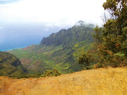
“How much farther?” we ask about the vista above the island’s famously scenic Napali coastline. Turns out we still have a mile or so of hiking before the boardwalk ends at the lookout: a small platform situated atop a 4,030-foot drop into Kauai’s northwest shore.
We pause for a moment to consider our options. Turn around here and we’ll finish an already spectacular excursion well before sunset. Push on and there’s a chance we’ll later be fumbling around in fading daylight. The four of us glance at one another and come to an almost instant consensus: We’re pushing on to Kilohana.
We had arrived at Kokee State Park shortly after midday with backpacks ready for a day hike but no set plan. Tucked into the often cloud-enshrouded highlands of Kauai’s northwest side, the 4,345-acre park maintains more than 45 miles of hiking paths—a few leading to sweeping views of Napali’s sea cliffs and Waialeale’s emerald slopes, others to waterfalls and glimpses of the red-clay walls of neighboring Waimea Canyon further downslope. In all, Kokee offers a hiker’s paradise of 17 designated trails.
Located near the start of several trailheads is Kokee Natural History Museum, a small, rustic space chockablock with facts and figures about the area’s native forests and rare Hawaiian birds, volcanic geology, and pioneering people. Staff members are on hand every day of the year to share the park’s story along with maps, weather forecasts and tips about current trail conditions.
Inquiring about trails we could complete before dark, we were told that the often mist-covered Pihea and Alakai Swamp trails, which lead to Kilohana Lookout, were in perfect shape due to a recent dry spell. If we were up for a quick-paced, eight-mile round trip, this was the hike for us. Suddenly, we had a plan.
A four-mile drive beyond the museum on Kokee Road took us to end-of-the-road Puu Kila Lookout, near the trailhead for the Pihea and Alakai Swamp treks. Starting at sea level in Waimea town on Kauai’s dry, sunny west side, Kokee Road winds skyward for 19 miles, straddling the edge of Waimea Canyon early on before ending near the 4,200-foot elevation of Kokee State Park.

Hikers navigate most of the Alakai Swamp Trail by way of a boardwalk.
A state-posted sign at Puu Kila, which overlooks pristine, much-photographed Kalalau Valley, points out Mount Waialeale. Its 5,148-foot summit eight miles southeast of us, Waialeale boasts average annual rainfall of more than 450 inches. Kokee’s forests get about 70 inches of rainfall annually, much of it concentrated between October and May. Daytime temperatures at Kokee range from 45 degrees Fahrenheit in January to 68 degrees in July.
The day of our hike was one of the good ones, weather-wise: warm, T-shirt temperatures, light trade winds and mostly clear views of the landscape and skies.
Pihea Trail begins as a wide path, dotted with glittering, crushed granite. The trail then traces a back rim of Kalalau Valley for a half-mile before meandering into a forest of ohia trees flecked with bristled fiery-red lehua blossoms. Lucky for us, the afternoon’s dry weather meant no slippery patches on the clay soil that soon dominated the path. Navigating the scores of dried-out footholds in these climbing areas even wound up being fun.
The boardwalk begins a mile or so into Pihea Trail and spans a patchwork of ever-slick spots. Two sets of sturdy wooden staircases ease our travel through steep descents and ascents. Pihea Trail ends at gurgling Kawaikoi Stream, where the path leading to the wide-open wetlands of the Alakai Swamp Trail begins.
Emerging from the sun-streaked forest, we’re surrounded by the ankle-deep, murky water of the Alakai Swamp. The swamp, on elevated flatlands above Napali, is vegetation-packed, but my nose detects only fresh, almost-fragrant air. No swampy stench here. I manage to avoid stumbling off the boardwalk by keeping my eyes focused on the path ahead of me, stopping on occasion to survey the profiles of nearby ridgelines and summits.
Assembly of the boardwalk and stairs began in the early 1990s, but that did not mark the first time a trail had been blazed through the area. During World War II, the United States Signal Corps strung a backup telephone line through the bog to connect Kokee with Waimea on Kauai’s west side and Hanalei further northeast. Some of that telephone line’s weather-beaten poles still rest alongside the final stretches of the Alakai Swamp Trail.
Long before any trails were in place, hunters, botanists and others explored these wetlands as well. Even Hawaii’s Queen Emma made the arduous trek. On a January day in the early 1870s, perhaps much like this one, an entourage led the queen’s way to Kilohana Lookout with a makeshift path of fern-covered logs.
Finally at the breathtaking trail’s end, we are met with jaw-dropping views of velvety Wainiha Valley and crescent-shaped Hanalei Bay from the Napali Coast’s highest reaches. Taking in the natural splendor before me, I have no doubt that the plucky Queen Emma, known for her ardent love of the Garden Isle, must have been equally pleased with the view before her.
Bonus? Even with ample time at Kilohana Lookout, we make it back to the trailhead with daylight to spare.