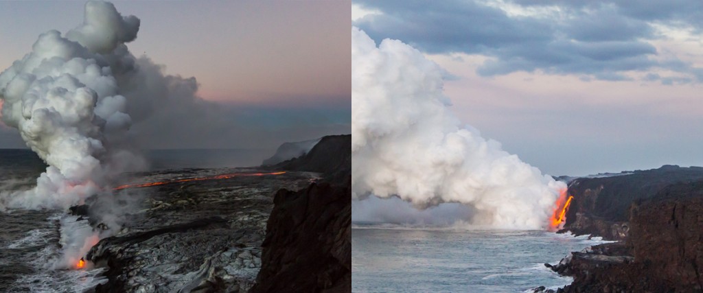
Before and after photos of the Hawaii Island lava delta collapse
At Kamokuna, the land is constantly changing.
Now you see it, now you don’t.
Such is the powerful display of raw nature that occurred at Kamokuna on the Island of Hawaii where visitors have been able to observe the formation of a lava delta as the 61g lava flow tumbled over sea cliffs into the Pacific since last summer.
Now in the following before-and-after images, a photographer, Warren Fintz, who specializes in landscape portraits, lets you compare the various states of the lava flow and help better understand and visualize it.
BEFORE

Photo: Warren Fintz
In the ‘Before’ image, taken on October 11, 2016, you can see this new, unstable forming, during one of its most exuberant stages. It showcases the more or less 20-plus acres that eventually collapsed into the ocean suddenly at the end of 2016.
AFTER

Photo: Warren Fintz
In the ‘After’ image, taken on January 1, you can also see where the 4-acre cliff also crumbled into the sea. In the bottom right of the image is the formerly legal viewing area.
“For reference, the furthest points match,” Fintz, who regularly documents this area as part of his photography business, Epixx Adventures Photography, says. “Just below the river of lava in the ‘Before’ pic, there’s a spot of red lava. That’s where the reaming outcrop of land can be seen in the ‘After’ shot.”
“The ‘After’ picture shows the ruptured lava tube pouring steadily into the sea,” he adds. “It was all that was left from the Kamokuna flow on New Years Day, 2017.”