I tried to mentally will the gray clouds away as we approached the left turn to the posh Aina Haina neighborhood in East Oahu.
My husband and I, our dog in the back seat, were heading to the Wiliwilinui Ridge Trail and the drive over was becoming increasingly overcast.
The nearly 5-mile round-trip trail is known for its unimpeded views of East Oahu. From the top of the ridge, at an elevation just shy of 1,600 feet, you’re treated to a panorama of Waikiki, Honolulu, Waimanalo and Konahuanui, the highest peak in the Koolau Mountain range. That is unless clear skies aren’t in the forecast.

Photo: Mike Karas
Wiliwilinui Ridge sits to the left of the popular Koko Crater, and is part of three mountain ridges: Kuliouou, Hawaii Loa and Wiliwilinui. We had hiked Hawaii Loa and Kuliouou several times and thought, why not check out Wiliwilinui? All three share similar terrain, with introduced and indigenous flora and those stunning vistas. Wiliwilinui isn’t the shortest hike of the trio, but it’s the easiest and a great intro to Hawaii ridge hikes.
We pull up to the Waialae Iki subdivision guard shack; the trailhead is in a gated community. The friendly guard takes down our car’s license plate number and hands my husband a red laminated parking pass. There are a limited number of passes (we are No. 15). While this restricts trail access, it also means that it won’t be too crowded, a luxury on bustling Oahu.
We get the last parking spot. (You can only park in the designated parking lot near the trailhead.) We swap our slippers for socks and hiking boots, sling on our backpacks and get the dog ready. The blanketed sky holds steady above as we begin.
The Wiliwilinui Ridge Trail starts off nice and easy. In fact, the beginning is a paved road. It soon gives way to a wide dirt road, which continues for just over a mile. The well-maintained trail was built by the U.S. Army in 1941 and was originally used as a service road. We walk along at a leisurely pace, letting our dog sniff around as we stroll beneath Formosa koa and waiawi, or yellow strawberry guava trees. While it’s a hazy day, we still have good views of Aina Haina and the rolling green mountains.
Roughly an hour in, we come to a clearing in the trail. I read online beforehand that there used to be a colorfully painted wooden swing hanging from a tree, but it was removed years ago. We take a break here and drink water. Up ahead is where the real hiking begins.
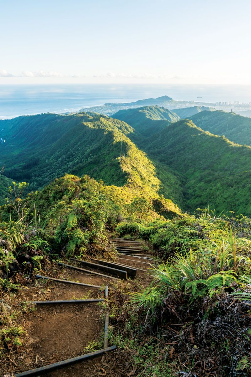
but the real hiking begins with these stairs.
Photo: Mike Karas
The clearing gives way to the trail’s first set of stairs—there are more than 10 sets in all—up to a nearly 1,600-foot elevation. The steps not only help prevent erosion along the ridge, they also help make it significantly easier to navigate the trail. (There are even ropes installed next to the trail’s trickiest stairs.) Good thing, because as we start our stair climb, it starts to lightly rain. The now narrower, inclined pathway becomes muddy. The dog loves it.
As we climb higher, we find ourselves enveloped in a cloud. Being shrouded in the misty air gives the hike a serene quality. It’s cool, quiet and secluded, making it easy to appreciate the effortless beauty of Hawaii. From here, on a clear day, Wiliwilinui’s neighboring ridgelines are visible. But this is not a clear day; instead we spot native species, such as red ohia lehua flowers, uluhe ferns and koa trees. In the distance, songbirds serenade.

Kualoa and Waimanalo await you.
Photo: Mike Karas
Eventually we reach a communications tower. A few minutes later, we come to a lone bench in a small clearing. A little muddy, but we made it. We stand looking out at the sea of placid white ahead. It isn’t the view we had in mind when we set out, but there is still something special about being surrounded by Mother Nature in this way. If it’s a clear day, you’ll be rewarded with sweeping views of east Honolulu, Waikiki, Kualoa and Waimanalo. From here, you can also see the three peaks of Olomana and Konahuanui. (Adventurous and seriously experienced hikers can continue on toward Hawaii Loa Ridge Trail or Lanipo Trail.)
We take our time heading back down, especially with the ground slick and muddy. (It takes us about 3 1/2 hours round trip.) We only see four other people on the trail this day; once they walk by, the clouds quickly swallow them. As we approach one of the last sets of stairs, the clouds start to clear, giving us a patchy peek at Honolulu and Waikiki, the ocean in the distance. Maybe my positive thoughts worked after all.
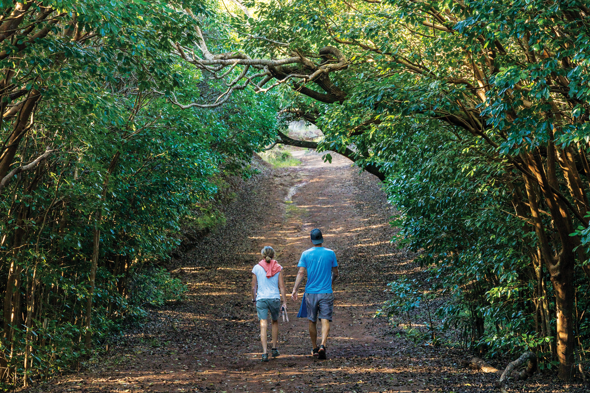
Photo: Mike Karas
Hiking the Wiliwilinui Ridge Trail
- Difficulty: Intermediate
- Length: 4.5 miles round trip
- Where it’s at: The trailhead is on Okoa Street in the gated Waialae Iki subdivision.
- Where to park: In the parking lot on Okoa Street; you can’t park elsewhere in the neighborhood.
- When to go: Start this hike early or midmorning; if all parking passes have been distributed, you’ll be turned away.
- What to bring: Water, snacks and sunscreen. Don’t forget your smartphone for photos.
- Tip: If you’re going specifically for the views, check the weather report beforehand.