Hiking Puu Waawaa, an ancient cinder cone on Hawaii Island
Tucked beyond an always-closed metal gate and cattle grate, the trails of Puu Waawaa Forest Reserve may be some of Kona’s best-kept secrets.
The sleepy reserve (on my recent weekend visit I saw more sheep than people) transports visitors from the thoroughfare of Highway 190, into dryland groves of ohia, Hawaiian sandalwood and other important native plants. The entire 37,600 acre region is enveloped in the sounds of rustling of tall, dry grasses and looks more like a southwestern prairie than how one might envision a “typical Hawaiian” landscape.
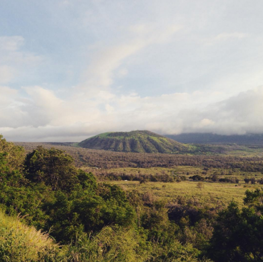
You’ll find it just before the tiny town of Puuanahulu, and 15 miles south and inland from the resorts at Waikoloa. There, Puu Waawaa, an unmistakable rounded mound juts high above slopes of Hualalai Volcano. It’s an ancient pyroclastic cinder cone—the oldest structure on the volcano—formed during an explosive burst of lava some 110,000 years ago.

Photo by fletcher_films/Instagram
Three trail options, totaling more than eight miles, allow you to explore plant life up close as well as climb the nearly 800 feet in elevation to the summit. Recent and regular rains an ominous clouds prevented me from attempting the summit on this particular visit, but the many flowering trees and plants meant there was lots to see on the other paths. I started on the 1.1-mile Halepepe Trail near the entrance.
I grabbed a trail map indicating native botanical highlights from the mailbox beneath the check-in register at the hiker’s station. Purple jacaranda trees and the unusual golden blooms of the southern silky oak native to Australia mark the overgrown trail. It wasn’t long before I spotted the trail’s namesake plant—with a shape not unlike a hala tree but filled with golden flowers. It and the slow-growing lama tree also seen on the trail are two of the five plants placed on a hula altar; both honor and represent the forest and the goddess of hula, Laka.
I also spotted the coffee-relative alahee, a native tree with surprisingly thick wood, along the Halapepe trail. Early Hawaiians used the sturdy wood as a tool to cut through other woods, and to make spears.

The flat loop trail alternates between a gravel base and jumbled lava rock. Interspersed in the black lumps were bits of scoria, a pumice-like stone, light-weight air-pocket infused ejections of Puu Waawaa. According to another brochure of geological information compiled by UH Manoa Geology instructor Thoma Shea, the Puu Waawaa is the only location where true pumice or obsidian has been found to date in the Hawaiian Islands. An ancient quarry for these stones, used to make tools and traded as a valuable Island resource, can be spotted along the summit trail and was in use until the early 1900s.
After the loop, I wandered up to the base of the Ohia Trail for better views of the cinder cone. Throughout Hualalai’s long eruptive history, its numerous and thick flows have blanketed its slopes several times over. Except, that is, for elevated Puu Waawaa and neighboring Puu Anahulu, a ridge easily spotted along the Halapepe Trail. Scientists estimate that the dense lava that comprises Puu Anahulu is newer than Puu Waawaa, and that this formation was created in an eruption that unleashed more lava than has been emitted over the last 35 years at Kilauea.

Photo by Maggie/Instagram
From the old road that leads to the Ohia and Cone trailheads, it’s easy to see the undulating nature of Puu Waawaa mound. Despite the usually dry region surrounding it—I even saw a cactus on my way up!—the ridges are erosional features formed by years of rainfall and are what give Puu Waawaa (“many-furrowed hill”) its name. You won’t spot these features on many other cinder cones in North Kona, and certainly not on the lumps that pock the climb up the Island-bisecting Saddle Road between Mauna Loa and Mauna Kea.
The Ohia Trail, a loop accessed by the same old paved road as the Cone Trail, had similar flora to the Halapepe Trail, but promised ohia flowering in colors beyond the typical red. I’ll have to come back for the more than seven mile round-trip, three-hour climb to the top of Puu Waawaa for its views of Mauna Kea, Mauna Loa, Kohala and the top of Hualalai.
Despite the fact that the DLNR’s Division of Forestry and Wildlife manages Puu Waawaa, volunteers maintain the trails here. For years the groups involved had hoped to expand to include more than these three public trails, but so far only extensions off the main trails have been created. In the future, there may be even more ways to explore this dryland forest and cinder cone-pocked landscape.
Puu Waawaa Forest Reserve — 6 a.m. til 6 p.m. daily • www.puuwaawaa.org