Lava is flowing on Kilauea! Here’s what you need to know about seeing it safely.
Kilauea has been continuously erupting for over 30 years, but that doesn’t mean lava has been putting on a non-stop spectacular within Hawaii Volcanoes National Park (HVNP). In recent years most park-based lava viewing has been the distant glow of the on-going gas eruption and lava lake in Halemaumau Crater. Not anymore.
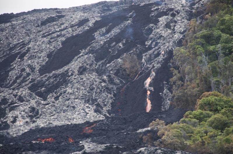
On July 1, an extension of the 9-year lava flow that has been oozing in mostly obscured, hard to reach and private forest came tumbling down a pali (cliff), partially within the park and within viewing distance. It’s now possible to see lava near the end of the newly constructed emergency access route, a gravel extension to the park’s Chain of Craters road.

Unlike streams from the same Puu Oo cone on Kilauea’s eastern rift zone that threatened Pahoa town last year, the new lava finger – dubbed 61g – is flowing over Pulama Pali and across a coastal plain in the abandoned Royal Gardens subdivision and not threatening local communities. According to the latest distance update from the USGS’ Hawaiian Volcano Observatory (HVO) before press time, the flow was about 0.6 miles from the sea on Sun, July 10. This turn of events is exciting for both residents and visitors alike—not only is this a new opportunity to witness the awesome powers of Pele, but this slow-moving mass (inching along lately at speeds around 40 yards per day) is headed toward the sea and has the potential to add to the Big Island’s bulk.
When the lava flows on Hawaii Island everyone goes. Here are some tips if you decide to join the masses:
Though the flow is near the park’s eastern boundary, the best viewing is in Kalapana 45 miles away by road. There, Hawaii County Civil Defense has established a lava viewing area for visitors with set hours – 3 p.m. til 9 p.m. daily. To reach it from the park, take Highway 11 toward Hilo to Highway 130. Follow Highway 130 to the end of the road. Park in the marked spots and walk to the gravel road, the new emergency access route. From here it’s a three-mile one-way flat but unshaded hike to the viewing area – take plenty of water, hiking boots and a hat. Though it may be tempting to arrive early and bypass the long hike by driving along the road, Hawaii County Civil Defense cautions traffic is limited to local residents and emergency vehicles and that the route will be monitored by security guards. There is no provided potable water, though some enterprising locals have started selling cold water and t-shirts from their driveways along the road. There are portable toilets at the viewing area.

Be aware that once you reach the viewing area, the lava still isn’t that close. The flow front will likely be more than a mile in the distance. But, because of its mass and incandescence, it’s hard to miss… especially after dusk! The last car is admitted for parking at 8 p.m. Last week visitors could easily spot the electric orange stream flowing like a waterfall down the pali and smoke clouds where it encountered trees during daylight hours. Conditions change from day to day so the time to visit is now!
Views from HVNP aren’t bad either. Drive to the end of Chain of Craters Road and park your car across from Holei Sea Arch. Follow the gravel road to see the flow. From this side it’s best to view the flow at night when the glow makes the distant stream easier to spot. Though, unlike the Civil Defense’s viewing area, you will have to pay National Park admission ($20/vehicle, valid for 7 days), the park remains open 24-hours a day.
For the latest updates on the flow, check the Hawaiian Volcano Observatory website.