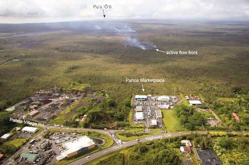
Kilauea volcano lava flow again threatening sole access roads to Pahoa town and Hawaii Island’s eastern tip

The ongoing Kilauea volcano lava flow, whose leading edge last month stopped short of crossing the main road through the Hawaii Island town of Pahoa after claiming a single residence, is now threatening the town’s largest grocery store and a major district intersection.
Since Nov. 19, a breakout from the former, now inactive, leading edge of the flow has steadily advanced toward another section of the Puna district town. Projections from the Hawaiian Volcano Observatory (HVO) show the flow on a course likely taking it through the Pahoa Marketplace shopping complex and crossing the intersection of Pahoa Village Road and Highway 130 if its progression continues.
Highway 130 is the only artery connecting Pahoa and the small communities of Hawaii Island’s easternmost tip with the rest of the island. Pahoa Village Road, which the former leading edge of the flow threatened to cross last month before stopping, is a small two-lane road running through Pahoa. Pahoa Marketplace is home to the Malama Market grocery store and a number of other small businesses.
As of this morning, the current active flow was .8 miles upslope from Pahoa Marketplace and the intersection of Pahoa Village Road and Highway 130. The flow advanced at a rate of 900 feet/day between Dec. 9 and 16, slowing to 400 feet between yesterday and today.

Hawaii County Civil Defense officials said in a statement this morning that area businesses were taking steps to prepare for a possible evacuation, and warned residents and visitors of possible traffic congestion along Pahoa Village Road and Highway 130. Yesterday, Malama Market and a handful of nearby businesses began shutting down in anticipation of the flow’s arrival.
An emergency bypass route via Railroad Avenue, an old farm road that the county has been clearing and widening since the flow first began threatening Pahoa in October, is set to open at noon on Saturday, according to Civil Defense officials. Another emergency bypass route, utilizing Hawaii Volcanoes National Park’s Chain of Craters Road, will likely open in the next few weeks.
HVO has set up several new live time-lapse webcams to monitor the progress toward the shopping center and the intersection. One camera faces the Pahoa Marketplace and another is located at the retail complex, facing the flow. You can see a complete listing and the links for all of HVO’s Kilauea volcano webcams here.

Situated 20-miles southeast of Hilo, Pahoa is part of Hawaii Island’s Puna district, which encompasses the island’s eastern-most tip. The current flow, which began on June 27, is part of a long-running eruption from the Puu Oo volcanic cone, on the eastern flank of Kilauea volcano.
Eruptions in the area have been continuous since 1983. According to USGS statistics, lava from the three-decade plus eruption has destroyed 215 structures and claimed nearly nine miles of highway.
HawaiiMagazine.com will continue to monitor news from Hawaiian Volcano Observatory and Hawaii County Civil Defense on the lava flow. We will update this story as necessary.
You can also follow the USGS Hawaiian Volcano Observatory as they monitor the situation.


